|
|
Antenna Structure Registration 1012221 |
 |
Registration Info | Registration Number: 1012221 |
| File Number: A0977419 |
| FAA Study: 69-LAX-2-OE |
| Status: Constructed |
| Date Constructed: 04/01/1996 |
| FAA EMI: N |
| NEPA: N |
Structure Info
| Structure Type: 2TOWER |
| Structure Coordinates: 34-13-27.0 N 118-3-48.0 W (NAD 83) |
| Structure Coordinates: 34-13-27.0 N 118-03-44.8 W (Converted to NAD 27) |
| Structure Address: Main Twr Mount Wilson Antenna Farm 9.5 Mi N El Monte Arpt |
| Structure City: El Monte, CA |
| Structure County: Los Angeles County |
| Painting & Lighting Info |
FAA Chapters: NONE |
| Elevation Info |
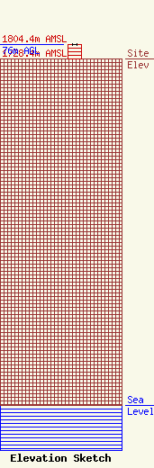
Site Elevation: 1728.4 meters (5671 ft) |
| Height of Structure: 74.7 meters (245 feet) |
| Overall Height Above Ground: 76 meters (249 feet) |
| Overall Height Above Mean Sea Level: 1804.4 meters (5920 feet) |
| Owner Info | Fox Television Stations, LLC
400 N. Capitol Street, NW
Washington, DC 20001
(202) 824-6522
jdiscipio@21cf.com |
| Contact Info | Fox Television Stations, LLC
400 N. Capitol Street, NW
Washington, DC 20001
(202) 824-6522
jdiscipio@21cf.com |
