|
|
Antenna Structure Registration 1012103 |
 |
Registration Info | Registration Number: 1012103 |
| File Number: A1153216 |
| FAA Study: 2019-ASW-14102-OE |
| FAA Issue Date: 09/23/2019 |
| Status: Constructed |
| Date Constructed: 06/07/1982 |
| NEPA: N |
Structure Info
| Structure Type: GTOWER |
| Structure Coordinates: 30-9-28.7 N 93-48-7.1 W (NAD 83) |
| Structure Coordinates: 30-09-27.9 N 93-48-06.5 W (Converted to NAD 27) |
| Structure Address: Fm 1078 & Gum Bulley Bayou (orange Field #4215) |
| Structure City: Orange, TX |
| Structure County: Orange County |
| Painting & Lighting Info |
FAA Circular #: 70/7460-1L |
FAA Chapters: 4, 8, 12 |
| Elevation Info |
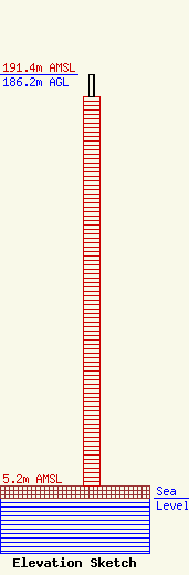
Site Elevation: 5.2 meters (17 ft) |
| Height of Structure: 175.9 meters (577 feet) |
| Overall Height Above Ground: 186.2 meters (611 feet) |
| Overall Height Above Mean Sea Level: 191.4 meters (628 feet) |
| Owner Info | American Towers LLC
10 Presidential Way
Woburn, MA 01801
(781) 926-4500
faa-fcc@americantower.com |
| Contact Info | American Towers, LLC
10 Presidential Way
Woburn, MA 01801
(781) 926-4500
faa-fcc@americantower.com |
