|
|
Antenna Structure Registration 1062995 |
 |
Registration Info | Registration Number: 1062995 |
| File Number: A1171853 |
| FAA Study: 2013-AWP-2801-OE |
| FAA Issue Date: 06/14/2013 |
| Status: Constructed |
| Date Constructed: 11/01/1987 |
| FAA EMI: N |
| NEPA: N |
Structure Info
| Structure Type: LTOWER |
| Structure Coordinates: 39-18-59.0 N 119-53-4.0 W (NAD 83) |
| Structure Coordinates: 39-18-59.3 N 119-53-00.3 W (Converted to NAD 27) |
| Structure Address: 22224 Mount Rose Highway (306802) |
| Structure City: Incline Village, NV |
| Structure County: Washoe County |
| Painting & Lighting Info |
FAA Chapters: NONE |
Remarks: PRIOR STUDY 2004-AWP-2448-OE |
Remarks: Removed expiration date from determination. Scenario 1./jjs/case#635066 |
Remarks: PRIOR STUDY 2004-AWP-2448-OE |
Remarks: Removed expiration date from determination. Scenario 1./jjs/case#635066 |
| Elevation Info |
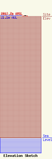
Site Elevation: 2892.6 meters (9490 ft) |
| Height of Structure: 18.3 meters (60 feet) |
| Overall Height Above Ground: 21.1 meters (69 feet) |
| Overall Height Above Mean Sea Level: 2913.7 meters (9559 feet) |
| Owner Info | MT. ROSE DEVELOPMENT COMPANY
22222 MT. ROSE HWY
RENO, NV 89511
(775) 849-0704
ps@skirose.com |
| Contact Info | MT. ROSE DEVELOPMENT COMPANY
22222 MT. ROSE HWY
RENO, NV 89511
PAUL SENFT
(775) 849-0704
ps@skirose.com |
