|
|
Antenna Structure Registration 1212684 |
 |
Registration Info | Registration Number: 1212684 |
| File Number: A0194802 |
| FAA Study: 99-ANM-0327-OE |
| FAA Issue Date: 02/23/2000 |
| Status: Constructed |
| Date Constructed: 06/04/2001 |
| FAA EMI: N |
| NEPA: N |
Structure Info
| Structure Type: TOWER |
| Structure Coordinates: 37-3-49.9 N 113-34-22.8 W (NAD 83) |
| Structure Coordinates: 37-03-50.0 N 113-34-20.0 W (Converted to NAD 27) |
| Structure Address: Webb Hill |
| Structure City: Saint George, UT |
| Structure County: Washington County |
| Painting & Lighting Info |
FAA Chapters: NONE |
Remarks: Removed expiration and final dates from determination. Scenario 2./jjs/case#635066 |
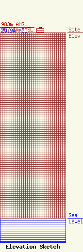
| Elevation Info |
Site Elevation: 957.1 meters (3140 ft) |
| Height of Structure: 21.3 meters (70 feet) |
| Overall Height Above Ground: 25.9 meters (85 feet) |
| Overall Height Above Mean Sea Level: 983 meters (3225 feet) |
| Owner Info | University of Utah - Utah Education Network
101 S. Wasatch Dr.
Salt Lake City, UT 84112
(801) 581-7777
rscott@uen.org |
| Contact Info | Utah Education Network
101 S. Wasatch Dr.
Salt Lake City, UT 84112
Louise Tonin
(801) 581-3576
ltonin@media.utah.edu |
