|
|
Antenna Structure Registration 1202623 |
 |
Registration Info | Registration Number: 1202623 |
| File Number: A0142795 |
| FAA Study: 81-ARM-243-OE |
| FAA Issue Date: 05/11/1981 |
| Status: Constructed |
| Date Constructed: 11/15/1991 |
| FAA EMI: N |
| NEPA: N |
Structure Info
| Structure Type: TOWER |
| Structure Coordinates: 44-25-32.9 N 100-21-29.4 W (NAD 83) |
| Structure Coordinates: 44-25-33.0 N 100-21-27.9 W (Converted to NAD 27) |
| Structure Address: On Snake Butte, 2 1/2 Mi N 1/2 Mi Nw Of Intersection Hwys 14 & 1804 |
| Structure City: Pierre, SD |
| Structure County: Hughes County |
| Painting & Lighting Info |
FAA Chapters: NONE |
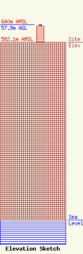
| Elevation Info |
Site Elevation: 582.1 meters (1910 ft) |
| Height of Structure: 51.8 meters (170 feet) |
| Overall Height Above Ground: 57.9 meters (190 feet) |
| Overall Height Above Mean Sea Level: 640 meters (2100 feet) |
| Owner Info | Communications Center Inc
1034
Pierre, SD 57501
(605) 224-1676
|
| Contact Info | Schwaninger & Associates
1835 K Street, NW, Suite 650
Washington, DC 20006
Benjamin Aron
(202) 223-8837
bjaron@sa-lawywers.net |
