|
|
Antenna Structure Registration 1039812 |
 |
Registration Info | Registration Number: 1039812 |
| File Number: A0126308 |
| FAA Study: 88-ASW-0391-OE |
| FAA Issue Date: 03/28/1988 |
| Status: Granted |
| FAA EMI: N |
| NEPA: N |
Structure Info
| Structure Type: TOWER |
| Structure Coordinates: 28-26-43.0 N 97-45-51.0 W (NAD 83) |
| Structure Coordinates: 28-26-42.0 N 97-45-50.0 W (Converted to NAD 27) |
| Structure Address: Us 181 And Linney Ln |
| Structure City: Beeville, TX |
| Structure County: Bee County |
| Painting & Lighting Info |
FCC Paragraph(s): 1, 3, 11, 21 |
Remarks: RED LIGHTS/PAINT |
| Elevation Info |
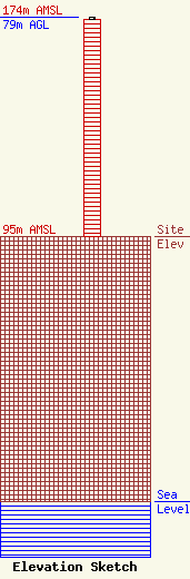
Site Elevation: 95 meters (312 ft) |
| Height of Structure: 78 meters (256 feet) |
| Overall Height Above Ground: 79 meters (259 feet) |
| Overall Height Above Mean Sea Level: 174 meters (571 feet) |
| Owner Info | CJS Pinnacle Petroleum Services, LLC
280
Beeville, TX 78104
(361) 358-1017
|
| Info |
