|
|
Antenna Structure Registration 1245477 |
 |
Registration Info | Registration Number: 1245477 |
| File Number: A1254626 |
| FAA Study: 2017-ASW-9136-OE |
| FAA Issue Date: 07/05/2017 |
| Status: Constructed |
| Date Constructed: 10/19/2017 |
| NEPA: N |
Structure Info
| Structure Type: GTOWER |
| Structure Coordinates: 32-18-28.6 N 93-58-34.7 W (NAD 83) |
| Structure Coordinates: 32-18-28.0 N 93-58-34.0 W (Converted to NAD 27) |
| Structure Address: 0.25 Miles N. Of Springridge-tx State Line Rd., 1.5 Miles W. Of Springridge, La |
| Structure City: Springridge, LA |
| Structure County: Caddo Parish |
| Painting & Lighting Info |
FAA Circular #: 70/7460-1L |
FAA Chapters: 4, 6, 12 |
Remarks: PRIOR STUDY 2004-ASW-4541-OE |
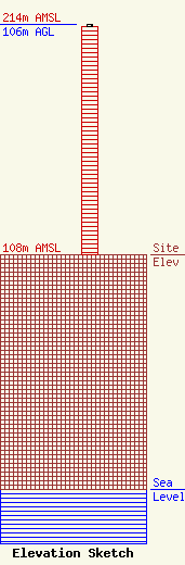
| Elevation Info |
Site Elevation: 108 meters (354 ft) |
| Height of Structure: 105 meters (344 feet) |
| Overall Height Above Ground: 106 meters (348 feet) |
| Overall Height Above Mean Sea Level: 214 meters (702 feet) |
| Owner Info | 6102 Seawall LLC
817 Blenheim Place
Tyler, TX 75703
(903) 508-6888
rodney@kvne.com |
| Contact Info | 6102 Seawall LLC
817 Blenheim Place
Tyler, TX 75703
(903) 508-6888
rodney@kvne.com |
