|
|
Antenna Structure Registration 1010495 |
 |
Registration Info | Registration Number: 1010495 |
| File Number: A1228551 |
| FAA Study: 97-ASW-2475-OE |
| FAA Issue Date: 09/08/1997 |
| Status: Constructed |
| Date Constructed: 09/09/1996 |
| FAA EMI: N |
| NEPA: N |
Structure Info
| Structure Type: TOWER |
| Structure Coordinates: 35-58-31.0 N 91-20-9.0 W (NAD 83) |
| Structure Coordinates: 35-58-30.7 N 91-20-08.5 W (Converted to NAD 27) |
| Structure Address: Lawrence Cr 2110 & Hwy 117 |
| Structure City: Strawberry, AR |
| Structure County: Lawrence County |
| Painting & Lighting Info |
FAA Circular #: 70/7460-1H |
FAA Chapters: 4, 8, 13 |
Remarks: SUPERSEDES STUDY #95-ASW-2454-OE. |
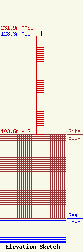
| Elevation Info |
Site Elevation: 103.6 meters (340 ft) |
| Height of Structure: 121.9 meters (400 feet) |
| Overall Height Above Ground: 128.3 meters (421 feet) |
| Overall Height Above Mean Sea Level: 231.9 meters (761 feet) |
| Owner Info | SBC Tower Holdings LLC
50 Royal Little Dr
Providence, RI 02904
(855) 699-7073
ATTNRC@att.com |
| Info |
