|
|
Antenna Structure Registration 1238168 |
 |
Registration Info | Registration Number: 1238168 |
| File Number: A1376794 |
| FAA Study: 2002-ASW-4372-OE |
| FAA Issue Date: 01/31/2003 |
| Status: Constructed |
| Date Constructed: 03/24/2003 |
| FAA EMI: N |
| NEPA: N |
Structure Info
| Structure Type: TOWER |
| Structure Coordinates: 34-16-19.3 N 98-25-31.2 W (NAD 83) |
| Structure Coordinates: 34-16-19.0 N 98-25-30.0 W (Converted to NAD 27) |
| Structure Address: Near Randlett Ok |
| Structure City: Randlett, OK |
| Structure County: Cotton County |
| Painting & Lighting Info |
FAA Circular #: 70/7460-1K |
FAA Chapters: 3, 4, 5, 12 |
Remarks: Removed final date from determination. Scenario 3./jjs/case#635066 |
Remarks: PRIOR STUDY 1995-ASW-1783-OE |
Remarks: Removed final date from determination. Scenario 3./jjs/case#635066 |
Remarks: PRIOR STUDY 1995-ASW-1783-OE |
| Elevation Info |
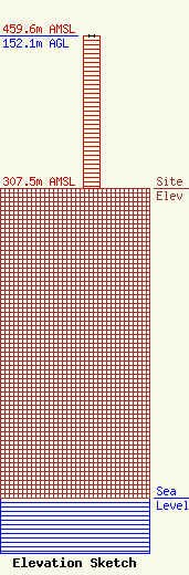
Site Elevation: 307.5 meters (1009 ft) |
| Height of Structure: 152.1 meters (499 feet) |
| Overall Height Above Ground: 152.1 meters (499 feet) |
| Overall Height Above Mean Sea Level: 459.6 meters (1508 feet) |
| Owner Info | K-LOVE, Inc.
2000 Reams Fleming Boulevard
Franklin, TN 37064
(916) 251-1600
fccdocumentdistribution@emfbroadcasting.com |
| Contact Info | K-LOVE, Inc.
2000 Reams Fleming Boulevard
Franklin, TN 37064
(916) 251-1600
fccdocumentdistribution@emfbroadcasting.com |
