|
|
Antenna Structure Registration 1207512 |
 |
Registration Info | Registration Number: 1207512 |
| File Number: A0654157 |
| FAA Study: 99-ASW-3397-OE |
| FAA Issue Date: 10/20/1999 |
| Status: Constructed |
| Date Constructed: 01/12/2001 |
| FAA EMI: N |
| NEPA: N |
Structure Info
| Structure Type: TOWER |
| Structure Coordinates: 30-38-10.7 N 93-2-33.5 W (NAD 83) |
| Structure Coordinates: 30-38-10.0 N 93-02-32.9 W (Converted to NAD 27) |
| Structure Address: Hwy 113, Dry Creek, La |
| Structure City: Deridder, LA |
| Structure County: Beauregard Parish |
| Painting & Lighting Info |
FAA Circular #: 70/7460-1J |
FAA Chapters: 3, 4, 5, 13 |
Remarks: Removed expiration date from determination. Scenario 1./jjs/case#635066 |
| Elevation Info |
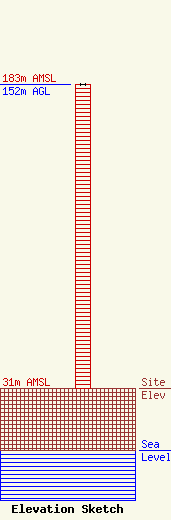
Site Elevation: 31 meters (102 ft) |
| Height of Structure: 152 meters (499 feet) |
| Overall Height Above Ground: 152 meters (499 feet) |
| Overall Height Above Mean Sea Level: 183 meters (600 feet) |
| Owner Info | AMERICAN FAMILY ASSOCIATION
P.O. DRAWER 2440
TUPELO, MS 38803
(662) 844-8888
JES@AFA.NET |
| Info |
