|
|
Antenna Structure Registration 1042962 |
 |
Registration Info | Registration Number: 1042962 |
| File Number: A1194774 |
| FAA Study: 88-ASO-1688-OE |
| Status: Constructed |
| Date Constructed: 07/18/1988 |
| FAA EMI: N |
| NEPA: N |
Structure Info
| Structure Type: TOWER |
| Structure Coordinates: 32-47-57.0 N 79-53-49.0 W (NAD 83) |
| Structure Coordinates: 32-47-56.4 N 79-53-49.7 W (Converted to NAD 27) |
| Structure Address: 210 W Coleman Blvd |
| Structure City: Mount Pleasant, SC |
| Structure County: Charleston County |
| Painting & Lighting Info |
FCC Paragraph(s): 1, 3, 6, 15, 21 |
| Elevation Info |
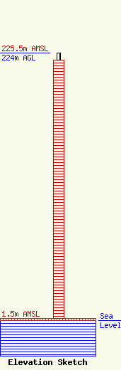
Site Elevation: 1.5 meters (5 ft) |
| Height of Structure: 218 meters (715 feet) |
| Overall Height Above Ground: 224 meters (735 feet) |
| Overall Height Above Mean Sea Level: 225.5 meters (740 feet) |
| Owner Info | Nexstar Media Inc.
545 E. John Carpenter Freeway
Irving, TX 75062
(972) 373-8800
jasroberts@nexstar.tv |
| Contact Info | Nexstar Media Inc.
545 E. John Carpenter Freeway
Irving, TX 75062
Jason Roberts
(972) 373-8800
jasroberts@nexstar.tv |
