|
|
Antenna Structure Registration 1044277 |
 |
Registration Info | Registration Number: 1044277 |
| File Number: A0495139 |
| FAA Study: 2004-ASO-5066-OE |
| FAA Issue Date: 09/09/2004 |
| Status: Constructed |
| Date Constructed: 01/06/2006 |
| FAA EMI: N |
| NEPA: N |
Structure Info
| Structure Type: TOWER |
| Structure Coordinates: 35-9-40.3 N 85-18-51.9 W (NAD 83) |
| Structure Coordinates: 35-09-40.0 N 85-18-52.0 W (Converted to NAD 27) |
| Structure Address: Fairmount Rd |
| Structure City: Walden, TN |
| Structure County: Hamilton County |
| Painting & Lighting Info |
FAA Chapters: NONE |
Remarks: PRIOR STUDY 1966-MEM-149-OE |
| Elevation Info |
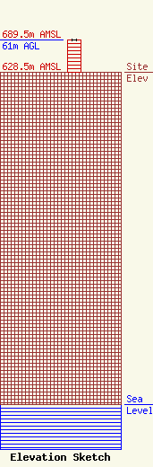
Site Elevation: 628.5 meters (2062 ft) |
| Height of Structure: 61 meters (200 feet) |
| Overall Height Above Ground: 61 meters (200 feet) |
| Overall Height Above Mean Sea Level: 689.5 meters (2262 feet) |
| Owner Info | SARKES TARZIAN INC DBA = WRCB TV
900 WHITEHALL RD
CHATTANOOGA, TN 37405-3247
(423) 267-5412
TTOLAR@WRCBTV.COM |
| Contact Info | Leventhal Senter & Lerman PLLC
2000 K Street, NW, Suite 600
Washington, DC 20006-1809
Brian Madden
(202) 429-8970
bmadden@lsl-law.com |
