|
|
Antenna Structure Registration 1054179 |
 |
Registration Info | Registration Number: 1054179 |
| File Number: A1369593 |
| FAA Study: 2016-ASO-23753-OE |
| FAA Issue Date: 11/21/2016 |
| Status: Constructed |
| Date Constructed: 01/05/1999 |
| NEPA: N |
Structure Info
| Structure Type: GTOWER |
| Structure Coordinates: 32-36-26.8 N 83-36-8.3 W (NAD 83) |
| Structure Coordinates: 32-36-26.3 N 83-36-08.6 W (Converted to NAD 27) |
| Structure Address: 108 Wellborn Rd |
| Structure City: Warner Robins, GA |
| Structure County: Houston County |
| Painting & Lighting Info |
FAA Circular #: 70/7460-1J |
FAA Chapters: 4, 6, 13 |
Remarks: OM&L to remain the same as prior study = 24-HR MED-STROBES |
Remarks: PRIOR STUDY 1998-ASO-7283-OE |
Remarks: OM&L to remain the same as prior study = 24-HR MED-STROBES |
Remarks: PRIOR STUDY 1998-ASO-7283-OE |
| Elevation Info |
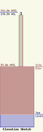
Site Elevation: 93.9 meters (308 ft) |
| Height of Structure: 101.2 meters (332 feet) |
| Overall Height Above Ground: 106.9 meters (351 feet) |
| Overall Height Above Mean Sea Level: 200.8 meters (659 feet) |
| Owner Info | Crown Castle Towers 06-2 LLC
2000 Corporate Drive
Canonsburg, PA 15317
(724) 416-2400
Regulatory.Department@crowncastle.com |
| Contact Info | Crown Castle
2000 Corporate Drive
Canonsburg, PA 15317
Tom Anderson
(724) 743-6330
Tom.Anderson@crowncastle.com |
