|
|
Antenna Structure Registration 1034945 |
 |
Registration Info | Registration Number: 1034945 |
| File Number: A1381765 |
| FAA Study: 2026-AGL-4962-OE |
| FAA Issue Date: 03/26/2026 |
| Status: Granted |
| Date Constructed: 12/10/2008 |
| NEPA: N |
Structure Info
| Structure Type: MTOWER |
| Structure Coordinates: 44-8-4.8 N 87-44-21.7 W (NAD 83) |
| Structure Coordinates: 44-08-04.8 N 87-44-21.4 W (Converted to NAD 27) |
| Structure Address: 3.15 Mi Nw |
| Structure City: Manitowoc, WI |
| Structure County: Manitowoc County |
| Painting & Lighting Info |
FAA Circular #: 70/7460-1M |
FAA Chapters: 4, 8, 15 |
Remarks: PRIOR STUDY 2023-AGL-11845-OE |
| Elevation Info |
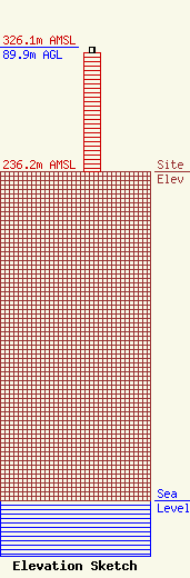
Site Elevation: 236.2 meters (775 ft) |
| Height of Structure: 86 meters (282 feet) |
| Overall Height Above Ground: 89.9 meters (295 feet) |
| Overall Height Above Mean Sea Level: 326.1 meters (1070 feet) |
| Owner Info | Nsight Tower Holdings, LLC
450 Security Blvd.
Green Bay, WI 54313
(920) 617-7500
legal@nsight.com |
| Contact Info | Vertical Bridge
750 Park of Commerce Drive
BOCA RATON, FL 33487
Richard Hickey
(561) 406-4015
fcc-faa@verticalbridge.com |
