|
|
Antenna Structure Registration 1204110 |
 |
Registration Info | Registration Number: 1204110 |
| File Number: A1366066 |
| FAA Study: 99-ASO-4025-OE |
| FAA Issue Date: 09/10/1999 |
| Status: Constructed |
| Date Constructed: 09/03/1998 |
| FAA EMI: N |
| NEPA: N |
Structure Info
| Structure Type: TOWER |
| Structure Coordinates: 36-5-51.3 N 87-23-34.5 W (NAD 83) |
| Structure Coordinates: 36-05-51.1 N 87-23-34.5 W (Converted to NAD 27) |
| Structure Address: 700 Pond Drive |
| Structure City: Dickson, TN |
| Structure County: Dickson County |
| Painting & Lighting Info |
FAA Chapters: NONE |
| Elevation Info |
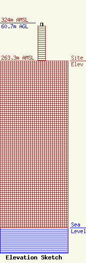
Site Elevation: 263.3 meters (864 ft) |
| Height of Structure: 55.5 meters (182 feet) |
| Overall Height Above Ground: 60.7 meters (199 feet) |
| Overall Height Above Mean Sea Level: 324 meters (1063 feet) |
| Owner Info | Pinnacle Towers LLC
2000 Corporate Drive
Canonsburg, PA 15317
(724) 416-2400
Regulatory.Department@crowncastle.com |
| Contact Info | Crown Castle
2000 Corporate Drive
Canonsburg, PA 15317
Tom Anderson
(724) 743-6330
Tom.Anderson@crowncastle.com |
