|
|
Antenna Structure Registration 1058417 |
 |
Registration Info | Registration Number: 1058417 |
| File Number: A0068633 |
| FAA Study: 94-AGL-3885-OE |
| FAA Issue Date: 04/03/1995 |
| Status: Constructed |
| Date Constructed: 06/01/1996 |
| NEPA: N |
Structure Info
| Structure Type: TOWER |
| Structure Coordinates: 40-21-6.0 N 80-39-22.0 W (NAD 83) |
| Structure Coordinates: 40-21-05.8 N 80-39-22.7 W (Converted to NAD 27) |
| Structure Address: 1 Km E Of Lovers Ln & Coal Hill Rd |
| Structure City: Steubenville, OH |
| Structure County: Jefferson County |
| Painting & Lighting Info |
FAA Circular #: 70/7460-1H |
FAA Chapters: 4, 6, 13 |
| Elevation Info |
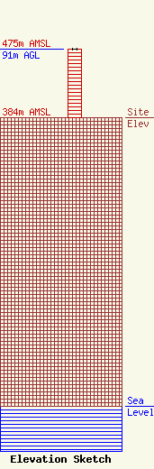
Site Elevation: 384 meters (1260 ft) |
| Height of Structure: 91 meters (299 feet) |
| Overall Height Above Ground: 91 meters (299 feet) |
| Overall Height Above Mean Sea Level: 475 meters (1558 feet) |
| Owner Info | JEFFERSON, COUNTY OF
301 MARKET ST
STEUBENVILLE, OH 43952
(740) 266-4150
|
