|
|
Antenna Structure Registration 1026427 |
 |
Registration Info | Registration Number: 1026427 |
| File Number: A1221931 |
| FAA Study: 2019-AEA-2715-OE |
| FAA Issue Date: 04/30/2019 |
| Status: Constructed |
| Date Constructed: 04/21/1997 |
| NEPA: N |
Structure Info
| Structure Type: GTOWER |
| Structure Coordinates: 38-16-21.0 N 77-29-45.0 W (NAD 83) |
| Structure Coordinates: 38-16-20.5 N 77-29-46.1 W (Converted to NAD 27) |
| Structure Address: Hudgins Rd |
| Structure City: Fredricksburg, VA |
| Structure County: Spotsylvania County |
| Painting & Lighting Info |
FAA Circular #: 70/7460-1L |
FAA Chapters: 4, 8, 12 |
Remarks: PRIOR STUDY 1997-AEA-1458-OE |
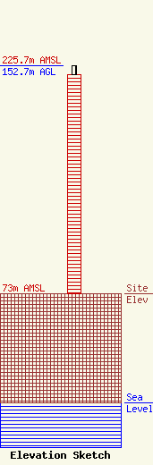
| Elevation Info |
Site Elevation: 73 meters (240 ft) |
| Height of Structure: 147 meters (482 feet) |
| Overall Height Above Ground: 152.7 meters (501 feet) |
| Overall Height Above Mean Sea Level: 225.7 meters (740 feet) |
| Owner Info | Subcarrier Communications Inc.
139 White Oak Lane
Old Bridge, NJ 08857
(732) 607-2828
subcom1@subcarrier.com |
| Contact Info | Subcarrier Communications Inc.
139 White Oak Lane
Old Bridge, NJ 08857
John Paleski
(732) 607-2828
subcom1@subcarrier.com |
