|
|
Antenna Structure Registration 1252255 |
 |
Registration Info | Registration Number: 1252255 |
| File Number: A0543766 |
| FAA Study: 2006-AEA-386-OE |
| FAA Issue Date: 02/21/2006 |
| Status: Constructed |
| Date Constructed: 01/01/1960 |
| FAA EMI: N |
| NEPA: N |
Structure Info
| Structure Type: TOWER |
| Structure Coordinates: 41-13-7.0 N 76-57-28.0 W (NAD 83) |
| Structure Coordinates: 41-13-06.7 N 76-57-29.1 W (Converted to NAD 27) |
| Structure Address: Skyline Drive |
| Structure City: South Williamsport, PA |
| Structure County: Lycoming County |
| Painting & Lighting Info |
FAA Chapters: NONE |
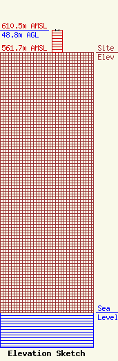
| Elevation Info |
Site Elevation: 561.7 meters (1843 ft) |
| Height of Structure: 48.8 meters (160 feet) |
| Overall Height Above Ground: 48.8 meters (160 feet) |
| Overall Height Above Mean Sea Level: 610.5 meters (2003 feet) |
| Owner Info | Maximum Impact Communications, Inc.
330 McElhattan Drive
999
McElhattan, PA 17748
(570) 769-2327
MFerriola@aol.com |
