|
|
Antenna Structure Registration 1062537 |
 |
Registration Info | Registration Number: 1062537 |
| File Number: A0979753 |
| FAA Study: 2011-AEA-3693-OE |
| FAA Issue Date: 09/20/2011 |
| Status: Constructed |
| Date Constructed: 10/20/2011 |
| NEPA: N |
Structure Info
|
| Structure Coordinates: 37-18-30.5 N 80-9-45.2 W (NAD 83) |
| Structure Coordinates: 37-18-30.0 N 80-09-46.0 W (Converted to NAD 27) |
| Structure Address: 4704 Mountain Park Drive |
| Structure City: Salem, VA |
| Structure County: Roanoke County |
| Painting & Lighting Info |
FAA Chapters: NONE |
Remarks: PRIOR STUDY 1998-AEA-1044-OE |
| Elevation Info |
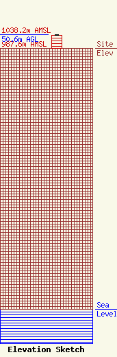
Site Elevation: 987.6 meters (3240 ft) |
| Height of Structure: 48.8 meters (160 feet) |
| Overall Height Above Ground: 50.6 meters (166 feet) |
| Overall Height Above Mean Sea Level: 1038.2 meters (3406 feet) |
| Info |
| Contact Info | Danny Ray Kane
914
Salem, VA 24153
Danny Kane
(540) 580-4225
danny@kanes.com |
