|
|
Antenna Structure Registration 1222245 |
 |
Registration Info | Registration Number: 1222245 |
| File Number: A1098786 |
| FAA Study: 00-AEA-3997-OE |
| FAA Issue Date: 01/29/2001 |
| Status: Constructed |
| Date Constructed: 02/12/2001 |
| NEPA: N |
Structure Info
| Structure Type: LTOWER |
| Structure Coordinates: 36-36-48.5 N 79-55-3.6 W (NAD 83) |
| Structure Coordinates: 36-36-48.0 N 79-55-04.5 W (Converted to NAD 27) |
| Structure Address: 2950 Chestnut Knob Road |
| Structure City: Martinsville, VA |
| Structure County: Henry County |
| Painting & Lighting Info |
FAA Chapters: NONE |
| Elevation Info |
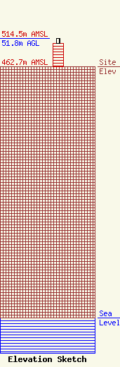
Site Elevation: 462.7 meters (1518 ft) |
| Height of Structure: 42.7 meters (140 feet) |
| Overall Height Above Ground: 51.8 meters (170 feet) |
| Overall Height Above Mean Sea Level: 514.5 meters (1688 feet) |
| Owner Info | GCSEAC, Inc.
5151
Martinsville, VA 24115-5151
(276) 632-9700
fcc@gcseac.com |
| Contact Info | GCSEAC, Inc.
5151
Martinsville, VA 24115-5151
(276) 632-9700
fcc@gcseac.com |
