|
|
Antenna Structure Registration 1022672 |
 |
Registration Info | Registration Number: 1022672 |
| File Number: A1158300 |
| FAA Study: 2016-ANE-3146-OE |
| FAA Issue Date: 08/22/2016 |
| Status: Constructed |
| Date Constructed: 10/01/1993 |
| NEPA: N |
Structure Info
| Structure Type: GTOWER |
| Structure Coordinates: 44-17-31.5 N 69-46-23.8 W (NAD 83) |
| Structure Coordinates: 44-17-31.3 N 69-46-25.6 W (Converted to NAD 27) |
| Structure Address: Dr. Mann Rd. |
| Structure City: Augusta, ME |
| Structure County: Kennebec County |
| Painting & Lighting Info |
FAA Chapters: NONE |
| Elevation Info |
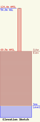
Site Elevation: 69.5 meters (228 ft) |
| Height of Structure: 54.9 meters (180 feet) |
| Overall Height Above Ground: 54.9 meters (180 feet) |
| Overall Height Above Mean Sea Level: 124.4 meters (408 feet) |
| Owner Info | Townsquare Media Augusta/Waterville, LLC
1 Manhattanville Road
Purchase, NY 10577
(203) 861-0900
fcccontact@townsquaremedia.com |
| Contact Info | Townsquare Media Augusta/Waterville, LLC
1 Manhattanville Road
Purchase, NY 10577
Mark Simpson
(203) 861-0900
fcccontact@townsquaremedia.com |
