|
|
Antenna Structure Registration 1204108 |
 |
Registration Info | Registration Number: 1204108 |
| File Number: A1239627 |
| FAA Study: 2022-ANE-2189-OE |
| FAA Issue Date: 03/02/2023 |
| Status: Constructed |
| Date Constructed: 05/24/2000 |
| NEPA: N |
Structure Info
| Structure Type: GTOWER |
| Structure Coordinates: 41-47-58.4 N 70-32-37.7 W (NAD 83) |
| Structure Coordinates: 41-47-58.0 N 70-32-39.6 W (Converted to NAD 27) |
| Structure Address: 391 Old Plymouth Road |
| Structure City: Bourne, MA |
| Structure County: Barnstable County |
| Painting & Lighting Info |
FAA Chapters: NONE |
Remarks: PRIOR STUDY 2001-ANE-669-OE |
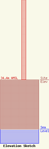
| Elevation Info |
Site Elevation: 34.4 meters (113 ft) |
| Height of Structure: 57.9 meters (190 feet) |
| Overall Height Above Ground: 60.9 meters (200 feet) |
| Overall Height Above Mean Sea Level: 95.3 meters (313 feet) |
| Owner Info | Industrial Tower and Wireless, LLC
40 Lone Street
Marshfield, MA 02050
(781) 319-1111
Kevin.Delaney@itwllc.com |
| Contact Info | Industrial Tower and Wireless, LLC
40 Lone Street
Marshfield, MA 02050
(781) 319-1111
Kevin.Delaney@itwllc.com |
