|
|
Antenna Structure Registration 1039830 |
 |
Registration Info | Registration Number: 1039830 |
| File Number: A0046853 |
| FAA Study: 97-AEA-3403-OE |
| FAA Issue Date: 01/08/1998 |
| Status: Constructed |
| Date Constructed: 01/01/1949 |
| NEPA: N |
Structure Info
| Structure Type: B |
| Structure Coordinates: 41-24-34.0 N 75-40-0.0 W (NAD 83) |
| Structure Coordinates: 41-24-33.7 N 75-40-01.3 W (Converted to NAD 27) |
| Structure Address: 149 Penn Ave |
| Structure City: Scranton, PA |
| Structure County: Lackawanna County |
| Painting & Lighting Info |
FAA Circular #: 70/7460-1J |
FAA Chapters: 3, 4, 5, 13 |
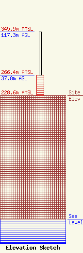
| Elevation Info |
Site Elevation: 228.6 meters (750 ft) |
| Height of Structure: 37.8 meters (124 feet) |
| Overall Height Above Ground: 117.3 meters (385 feet) |
| Overall Height Above Mean Sea Level: 345.9 meters (1135 feet) |
| Owner Info | SCRANTON TIMES LP DBA = WEJL WEZX
149 PENN AVE
SCRANTON, PA 18503
(717) 346-6555
ROCK107@ROCK107.COM |
