|
|
Antenna Structure Registration 1031010 |
 |
Registration Info | Registration Number: 1031010 |
| File Number: A1075386 |
| FAA Study: 2017-AGL-670-OE |
| FAA Issue Date: 01/12/2017 |
| Status: Constructed |
| Date Constructed: 05/19/2017 |
| NEPA: N |
Structure Info
| Structure Type: GTOWER |
| Structure Coordinates: 41-6-39.0 N 85-11-44.0 W (NAD 83) |
| Structure Coordinates: 41-06-38.8 N 85-11-44.1 W (Converted to NAD 27) |
| Structure Address: 3737 Hillegas Rd |
| Structure City: Fort Wayne, IN |
| Structure County: Allen County |
| Painting & Lighting Info |
FAA Circular #: 70/7460-1L |
FAA Chapters: 4, 8, 12 |
Remarks: PRIOR STUDY 2008-AGL-6009-OE |
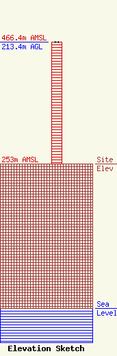
| Elevation Info |
Site Elevation: 253 meters (830 ft) |
| Height of Structure: 213 meters (699 feet) |
| Overall Height Above Ground: 213.4 meters (700 feet) |
| Overall Height Above Mean Sea Level: 466.4 meters (1530 feet) |
| Owner Info | TOWER MANAGEMENT INC
245 Edison Road, Suite 250
Mishawaka, IN 46545
(574) 286-6398
jlapehn@federatedmedia.com |
| Info |
