|
|
Antenna Structure Registration 1219833 |
 |
Registration Info | Registration Number: 1219833 |
| File Number: A0547243 |
| FAA Study: 00-ASO-7284-OE |
| FAA Issue Date: 10/30/2000 |
| Status: Constructed |
| Date Constructed: 09/16/2004 |
| FAA EMI: N |
| NEPA: N |
Structure Info
| Structure Type: TOWER |
| Structure Coordinates: 36-38-29.3 N 83-46-24.7 W (NAD 83) |
| Structure Coordinates: 36-38-29.0 N 83-46-25.0 W (Converted to NAD 27) |
| Structure Address: 1.75 Mi. N Of Kentucky 74 Off Beans Fork Road |
| Structure City: Middlesboro, KY |
| Structure County: Bell County |
| Painting & Lighting Info |
FAA Circular #: 70/7460-1K |
FAA Chapters: 3, 4, 5, 12 |
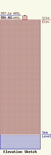
| Elevation Info |
Site Elevation: 921.1 meters (3022 ft) |
| Height of Structure: 30.5 meters (100 feet) |
| Overall Height Above Ground: 36 meters (118 feet) |
| Overall Height Above Mean Sea Level: 957.1 meters (3140 feet) |
| Owner Info | KENTUCKY, COMMONWEALTH OF DBA = KY EMERGENCY WARNING SYSTEM KEWS
100 Minuteman Pky Building 101
Frankfort, KY 40601
(502) 564-5397
william.hays@ky.gov |
| Contact Info | Commonwealth of Kentucky/Kentucky Emergency Warning System/GOT
100 Minuteman Pkwy/Building 101
Frankfort, KY 40601
Richard Miller
(502) 564-5397
richard.miller@mail.state.ky.us |
