|
|
Antenna Structure Registration 1207863 |
 |
Registration Info | Registration Number: 1207863 |
| File Number: A1063518 |
| FAA Study: 99-AEA-3290-OE |
| FAA Issue Date: 11/20/1999 |
| Status: Constructed |
| Date Constructed: 01/01/1959 |
| NEPA: N |
Structure Info
| Structure Type: B |
| Structure Coordinates: 39-56-59.0 N 75-10-13.0 W (NAD 83) |
| Structure Coordinates: 39-56-58.6 N 75-10-14.4 W (Converted to NAD 27) |
| Structure Address: Rooftop |
| Structure City: Philadephia, PA |
| Structure County: Philadelphia County |
| Painting & Lighting Info |
FAA Chapters: NONE |
Remarks: PRIOR FAA 87-AEA-2041-OE |
| Elevation Info |
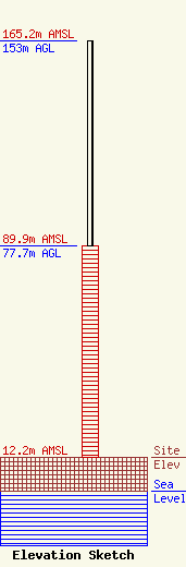
Site Elevation: 12.2 meters (40 ft) |
| Height of Structure: 77.7 meters (255 feet) |
| Overall Height Above Ground: 153 meters (502 feet) |
| Overall Height Above Mean Sea Level: 165.2 meters (542 feet) |
| Owner Info | RITTENHOUSE CLARIDGE, L.P.
201 SOUTH 18TH STREET, SUITE 300
PHILADELPHIA, PA 19103
(215) 546-2665
LBALESTRIERI@KAISERMAN.COM |
| Contact Info | RITTENHOUSE CLARIDGE, L.P.
201 SOUTH 18TH STREET, SUITE 300
PHILADELPHIA, PA 19103
(215) 546-2665
jcianfrani@kaiserman.com |
