|
|
Antenna Structure Registration 1318774 |
 |
Registration Info | Registration Number: 1318774 |
| File Number: A1213048 |
| FAA Study: 2020-ASO-37711-OE |
| FAA Issue Date: 12/29/2020 |
| Status: Constructed |
| Date Constructed: 09/01/2021 |
Structure Info
| Structure Type: GTOWER |
| Structure Coordinates: 33-44-17.4 N 90-39-29.3 W (NAD 83) |
| Structure Coordinates: 33-44-17.0 N 90-39-29.0 W (Converted to NAD 27) |
| Structure Address: South Side Of Highway 8, 3 Miles East Of Cleveland, Ms |
| Structure City: Cleveland, MS |
| Structure County: Sunflower County |
| Painting & Lighting Info |
FAA Circular #: 70/7460-1M |
FAA Chapters: 4, 6, 15 |
| Elevation Info |
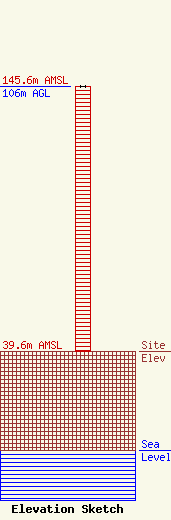
Site Elevation: 39.6 meters (130 ft) |
| Height of Structure: 106 meters (348 feet) |
| Overall Height Above Ground: 106 meters (348 feet) |
| Overall Height Above Mean Sea Level: 145.6 meters (478 feet) |
| Owner Info | CONTEMPORARY COMMUNICATIONS LLC
9408 GRAND GATE STREET
LAS VEGAS, NV 89143
(702) 482-9393
larry@larryfuss.com |
| Contact Info | CONTEMPORARY COMMUNICATIONS LLC
9408 GRAND GATE STREET
LAS VEGAS, NV 89143
LARRY FUSS
(702) 482-9393
larry@larryfuss.com |
