|
|
Antenna Structure Registration 1054538 |
 |
Registration Info | Registration Number: 1054538 |
| File Number: A0064160 |
| FAA Study: 98-ASO-2328-OE |
| FAA Issue Date: 07/14/1998 |
| Status: Constructed |
| Date Constructed: 10/01/1994 |
| NEPA: N |
Structure Info
| Structure Type: TOWER |
| Structure Coordinates: 36-25-53.0 N 82-8-15.0 W (NAD 83) |
| Structure Coordinates: 36-25-52.6 N 82-08-15.5 W (Converted to NAD 27) |
| Structure Address: 6247 Panhandle Road |
| Structure City: Hunter, TN |
| Structure County: Carter County |
| Painting & Lighting Info |
FAA Circular #: 70/7460-1J |
FAA Chapters: 3, 4, 5, 13 |
| Elevation Info |
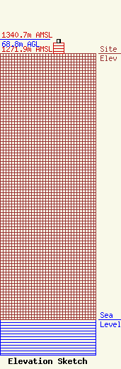
Site Elevation: 1271.9 meters (4173 ft) |
| Height of Structure: 51.6 meters (169 feet) |
| Overall Height Above Ground: 68.8 meters (226 feet) |
| Overall Height Above Mean Sea Level: 1340.7 meters (4399 feet) |
| Owner Info | HOLSTON VALLEY BROADCASTING CORPORATION
222 COMMERCE STREET
KINGSPORT, TN 37660
(423) 246-9578
|
