|
|
Antenna Structure Registration 1027986 |
 |
Registration Info | Registration Number: 1027986 |
| File Number: A0941374 |
| FAA Study: 2002-AEA-4140-OE |
| FAA Issue Date: 02/05/2003 |
| Status: Constructed |
| Date Constructed: 01/01/1957 |
| FAA EMI: N |
| NEPA: N |
Structure Info
|
| Structure Coordinates: 39-46-39.2 N 79-42-10.9 W (NAD 83) |
| Structure Coordinates: 39-46-38.9 N 79-42-11.7 W (Converted to NAD 27) |
| Structure Address: Ssr 2001 (088271) |
| Structure City: Uniontown, PA |
| Structure County: Fayette County |
| Painting & Lighting Info |
FAA Circular #: 70/7460-1G |
FAA Chapters: 4, 6, 9 |
Remarks: PRIOR STUDY 1987-AEA-802-OE |
| Elevation Info |
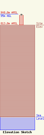
Site Elevation: 813.8 meters (2670 ft) |
| Height of Structure: 85.9 meters (282 feet) |
| Overall Height Above Ground: 95 meters (312 feet) |
| Overall Height Above Mean Sea Level: 908.8 meters (2982 feet) |
| Owner Info | R.M.Z. Holdings, Inc.
One Millennium Drive
Uniontown, PA 15401
(724) 451-1171
john.fonzo@ctsmgmt.com |
| Contact Info | R.M.Z. Holdings, Inc.
One Millennium Drive
Uniontown, PA 15401
John Fonzo
(724) 451-1171
john.fonzo@ctsmgmt.com |
