|
|
Antenna Structure Registration 1209826 |
 |
Registration Info | Registration Number: 1209826 |
| File Number: A0115293 |
| FAA Study: 99-ANE-0600-OE |
| FAA Issue Date: 12/30/1999 |
| Status: Granted |
| NEPA: N |
Structure Info
| Structure Type: TOWER |
| Structure Coordinates: 41-23-29.5 N 73-3-12.0 W (NAD 83) |
| Structure Coordinates: 41-23-29.2 N 73-03-13.6 W (Converted to NAD 27) |
| Structure Address: Intersection Progress Ln. & Silvermine Road |
| Structure City: Seymour, CT |
| Structure County: New Haven County |
| Painting & Lighting Info |
FAA Circular #: 70/7460-1J |
FAA Chapters: 4, 6, 13 |
Remarks: SUPPLEMENTAL NOTICE STATES STRUCTURE REACHED GREATEST HEIGHT ON 8-29-00 |
Remarks: Removed expiration date from determination. Scenario 1./jjs/case#635066 |
Remarks: SUPPLEMENTAL NOTICE STATES STRUCTURE REACHED GREATEST HEIGHT ON 8-29-00 |
| Elevation Info |
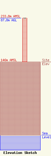
Site Elevation: 146 meters (479 ft) |
| Height of Structure: 87.8 meters (288 feet) |
| Overall Height Above Ground: 87.8 meters (288 feet) |
| Overall Height Above Mean Sea Level: 233.8 meters (767 feet) |
| Owner Info | EMAC Communications Company Inc
50 Olivia Street
Derby, CT 06418
(203) 735-7733
|
| Contact Info | Radio Communications Associates
12 Sweetbrier Raod
East Granby, CT 06026
Robert Fairbairn
(860) 651-3007
RFairb7672@aol.com |
