|
|
Antenna Structure Registration 1062561 |
 |
Registration Info | Registration Number: 1062561 |
| File Number: A1139117 |
| FAA Study: 2019-AGL-5574-OE |
| FAA Issue Date: 07/01/2019 |
| Status: Constructed |
| Date Constructed: 02/01/1996 |
| NEPA: N |
Structure Info
| Structure Type: GTOWER |
| Structure Coordinates: 41-40-9.3 N 86-48-13.7 W (NAD 83) |
| Structure Coordinates: 41-40-09.2 N 86-48-13.6 W (Converted to NAD 27) |
| Structure Address: 4266 N Cr 525 W (in23599-a Tower #2) |
| Structure City: Laporte, IN |
| Structure County: LaPorte County |
| Painting & Lighting Info |
FAA Chapters: NONE |
Remarks: PRIOR STUDY 1995-AGL-3845-OE |
| Elevation Info |
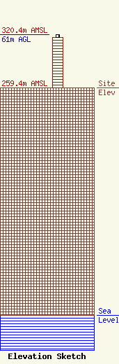
Site Elevation: 259.4 meters (851 ft) |
| Height of Structure: 58.2 meters (191 feet) |
| Overall Height Above Ground: 61 meters (200 feet) |
| Overall Height Above Mean Sea Level: 320.4 meters (1051 feet) |
| Owner Info | SBA Towers X, LLC
8051 Congress Avenue
Boca Raton, FL 33487
(561) 995-7670
ERoach@sbasite.com |
| Contact Info | SBA Towers X, LLC
8051 Congress Avenue
Boca Raton, FL 33487
(561) 995-7670
ERoach@sbasite.com |
