|
|
Antenna Structure Registration 1060097 |
 |
Registration Info | Registration Number: 1060097 |
| File Number: A0070515 |
| FAA Study: 89-AEA-0494-OE |
| FAA Issue Date: 08/11/1989 |
| Status: Constructed |
| Date Constructed: 07/01/1990 |
| NEPA: N |
Structure Info
| Structure Type: BANT |
| Structure Coordinates: 40-58-10.0 N 75-57-23.0 W (NAD 83) |
| Structure Coordinates: 40-58-09.7 N 75-57-24.3 W (Converted to NAD 27) |
| Structure Address: 217 Ninth Street |
| Structure City: Hazleton, PA |
| Structure County: Luzerne County |
| Painting & Lighting Info |
FAA Chapters: NONE |
| Elevation Info |
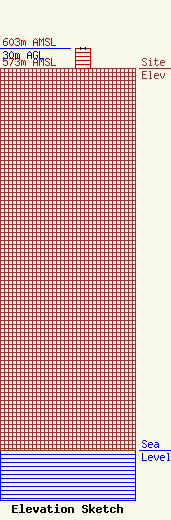
Site Elevation: 573 meters (1880 ft) |
| Height of Structure: 30 meters (98 feet) |
| Overall Height Above Ground: 30 meters (98 feet) |
| Overall Height Above Mean Sea Level: 603 meters (1978 feet) |
| Owner Info | GANS MULTIMEDIA PARTNERSHIP
217 EAST NINTH STREET
HAZLETON, PA 18201-0450
(717) 455-4251
|
