|
|
Antenna Structure Registration 1002612 |
 |
Registration Info | Registration Number: 1002612 |
| File Number: A1328022 |
| Status: Constructed |
| Date Constructed: 01/01/1968 |
| FAA EMI: N |
| NEPA: N |
Structure Info
| Structure Type: TOWER |
| Structure Coordinates: 42-54-55.0 N 76-46-27.0 W (NAD 83) |
| Structure Coordinates: 42-54-54.8 N 76-46-28.2 W (Converted to NAD 27) |
| Structure Address: Rt 116 At City Limits (also Known As E Bayard St Ext) |
| Structure City: Seneca Falls, NY |
| Structure County: Seneca County |
| Painting & Lighting Info |
FCC Paragraph(s): 1, 3, 12, 21 |
| Elevation Info |
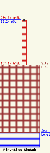
Site Elevation: 137.1 meters (450 ft) |
| Height of Structure: 91.4 meters (300 feet) |
| Overall Height Above Ground: 93.2 meters (306 feet) |
| Overall Height Above Mean Sea Level: 230.3 meters (756 feet) |
| Owner Info | CSN International, Inc.
4002 N 3300 E
391
TWIN FALLS, ID 83301
(208) 734-6633
DUSTIN.PAMPLONA@CSNRADIO.COM |
| Contact Info | CSN International, Inc.
2043 West Park Ct. NW.
5993
Salem, OR 97304
Kevin Smith
(503) 999-9528
KEVIN@CSNRADIO.COM |
