|
|
Antenna Structure Registration 1247769 |
 |
Registration Info | Registration Number: 1247769 |
| File Number: A0737152 |
| FAA Study: 2011-ASO-5357-OE |
| FAA Issue Date: 09/15/2011 |
| Status: Constructed |
| Date Constructed: 08/29/2005 |
| FAA EMI: N |
| NEPA: N |
Structure Info
| Structure Type: TOWER |
| Structure Coordinates: 33-19-0.0 N 83-31-39.3 W (NAD 83) |
| Structure Coordinates: 33-18-59.5 N 83-31-39.7 W (Converted to NAD 27) |
| Structure Address: 162 N. Keys Mill Rd (ga14381-a) |
| Structure City: Eatonton, GA |
| Structure County: Putnam County |
| Painting & Lighting Info |
FAA Circular #: 70/7460-1K |
FAA Chapters: 4, 8, 12 |
Remarks: PRIOR STUDY 2005-ASO-694-OE |
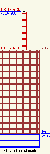
| Elevation Info |
Site Elevation: 168.6 meters (553 ft) |
| Height of Structure: 76.8 meters (252 feet) |
| Overall Height Above Ground: 78.3 meters (257 feet) |
| Overall Height Above Mean Sea Level: 246.9 meters (810 feet) |
| Owner Info | SBA Towers III LLC
8051 Congress Avenue
Boca Raton, FL 33487
(561) 995-7670
ERoach@sbasite.com |
| Contact Info | SBA Towers III LLC
8051 Congress Avenue
Boca Raton, FL 33487
Edward Roach
(561) 995-7670
ERoach@sbasite.com |
