|
|
Antenna Structure Registration 1218250 |
 |
Registration Info | Registration Number: 1218250 |
| File Number: A0654164 |
| FAA Study: 00-ASO-6645-OE |
| FAA Issue Date: 09/28/2000 |
| Status: Constructed |
| Date Constructed: 12/01/1993 |
| FAA EMI: Y |
| NEPA: N |
Structure Info
| Structure Type: TOWER |
| Structure Coordinates: 37-19-59.2 N 85-19-52.8 W (NAD 83) |
| Structure Coordinates: 37-19-59.0 N 85-19-52.9 W (Converted to NAD 27) |
| Structure Address: 1001 South Central Ave. |
| Structure City: Campbellsville, KY |
| Structure County: Taylor County |
| Painting & Lighting Info |
FAA Chapters: NONE |
| Elevation Info |
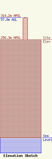
Site Elevation: 256.3 meters (841 ft) |
| Height of Structure: 57.9 meters (190 feet) |
| Overall Height Above Ground: 57.9 meters (190 feet) |
| Overall Height Above Mean Sea Level: 314.2 meters (1031 feet) |
| Owner Info | AMERICAN FAMILY ASSOCIATION
P.O. DRAWER 2440
TUPELO, MS 38803
(662) 844-8888
JES@AFA.NET |
| Info |
