|
|
Antenna Structure Registration 1222068 |
 |
Registration Info | Registration Number: 1222068 |
| File Number: A0654166 |
| FAA Study: 00-ASO-9524-OE |
| FAA Issue Date: 01/16/2001 |
| Status: Constructed |
| Date Constructed: 09/29/2001 |
| FAA EMI: N |
| NEPA: N |
Structure Info
| Structure Type: TOWER |
| Structure Coordinates: 36-59-32.1 N 88-59-19.2 W (NAD 83) |
| Structure Coordinates: 36-59-31.9 N 88-59-19.0 W (Converted to NAD 27) |
| Structure Address: Access Road, Ballard County |
| Structure City: Cunningham, KY |
| Structure County: Ballard County |
| Painting & Lighting Info |
FAA Circular #: 70/7460-1K |
FAA Chapters: 4, 7, 12 |
Remarks: PRIOR STUDY 99-ASO-3009-OE |
| Elevation Info |
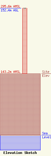
Site Elevation: 143.2 meters (470 ft) |
| Height of Structure: 152.4 meters (500 feet) |
| Overall Height Above Ground: 152.4 meters (500 feet) |
| Overall Height Above Mean Sea Level: 295.6 meters (970 feet) |
| Owner Info | AMERICAN FAMILY ASSOCIATION
P.O. DRAWER 2440
TUPELO, MS 38803
(662) 844-8888
JES@AFA.NET |
| Info |
