|
|
Antenna Structure Registration 1000437 |
 |
Registration Info | Registration Number: 1000437 |
| File Number: A0594793 |
| FAA Study: 91-AGL-0970-OE |
| Status: Constructed |
| Date Constructed: 07/12/1992 |
| FAA EMI: N |
| NEPA: N |
Structure Info
| Structure Type: TOWER |
| Structure Coordinates: 45-10-12.0 N 84-45-4.0 W (NAD 83) |
| Structure Coordinates: 45-10-12.0 N 84-45-03.9 W (Converted to NAD 27) |
| Structure Address: 02132 Tower Rd |
| Structure City: Vanderbilt, MI |
| Structure County: Charlevoix County |
| Painting & Lighting Info |
FAA Circular #: 70/7460-1G |
FAA Chapters: 3, 4, 5, 9 |
| Elevation Info |
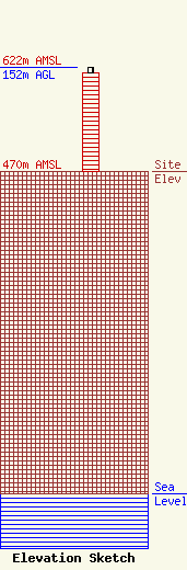
Site Elevation: 470 meters (1542 ft) |
| Height of Structure: 143 meters (469 feet) |
| Overall Height Above Ground: 152 meters (499 feet) |
| Overall Height Above Mean Sea Level: 622 meters (2041 feet) |
| Owner Info | CADILLAC TELECASTING, CO.
N. GALICIA DRIVE
22713
SUN CITY WEST, AZ 85375-2361
(602) 571-1052
JRNBOLEA@AOL.COM |
| Contact Info | WOMBLE CARLYLE SANDRIDGE & RICE, PLLC
1401 EYE STREET, NW
WASHINGTON, DC 20005
GREGG SKALL
(202) 857-4441
GSKALL@WCSR.COM |
