|
|
Antenna Structure Registration 1013183 |
 |
Registration Info | Registration Number: 1013183 |
| File Number: A0893443 |
| FAA Study: 2012-AGL-5825-OE |
| FAA Issue Date: 07/18/2012 |
| Status: Constructed |
| Date Constructed: 01/23/1997 |
| FAA EMI: N |
| NEPA: N |
Structure Info
| Structure Type: GTOWER |
| Structure Coordinates: 41-24-48.0 N 87-46-3.0 W (NAD 83) |
| Structure Coordinates: 41-24-47.9 N 87-46-02.8 W (Converted to NAD 27) |
| Structure Address: 1.15 Mi E |
| Structure City: Monee, IL |
| Structure County: Will County |
| Painting & Lighting Info |
FAA Circular #: 70/7460-1K |
FAA Chapters: 4, 8, 12 |
| Elevation Info |
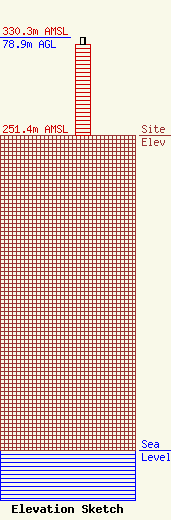
Site Elevation: 251.4 meters (825 ft) |
| Height of Structure: 73.1 meters (240 feet) |
| Overall Height Above Ground: 78.9 meters (259 feet) |
| Overall Height Above Mean Sea Level: 330.3 meters (1084 feet) |
| Owner Info | Tower Sites, Inc.
17640 W. National Ave.
New Berlin, WI 53146-3727
(262) 786-8330
tmichaels1@tower-sites.com |
| Contact Info | Tower Sites, Inc.
17640 W. National Ave.
New Berlin, WI 53146-3727
(262) 786-8330
tmichaels@tower-sites.com |
