|
|
Antenna Structure Registration 1285012 |
 |
Registration Info | Registration Number: 1285012 |
| File Number: A1048946 |
| FAA Study: 2012-ASO-8272-OE |
| FAA Issue Date: 08/28/2012 |
| Status: Constructed |
| Date Constructed: 04/05/2013 |
| FAA EMI: N |
Structure Info
| Structure Type: GTOWER |
| Structure Coordinates: 34-5-52.3 N 77-58-17.2 W (NAD 83) |
| Structure Coordinates: 34-05-51.7 N 77-58-18.2 W (Converted to NAD 27) |
| Structure Address: 9016 Funston Road |
| Structure City: Winnabow, NC |
| Structure County: Brunswick County |
| Painting & Lighting Info |
FAA Chapters: CONTINUE AS IS |
Remarks: PRIOR STUDY 2011-ASO-516-OE. CHAPTERS 3,4,5,12 CIRCULAR 1K. ADD SPECIAL CONDITION FOR RED LIGHT DEVIATION. |
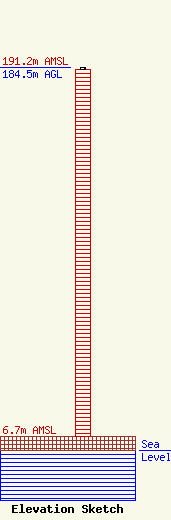
| Elevation Info |
Site Elevation: 6.7 meters (22 ft) |
| Height of Structure: 183.5 meters (602 feet) |
| Overall Height Above Ground: 184.5 meters (605 feet) |
| Overall Height Above Mean Sea Level: 191.2 meters (627 feet) |
| Owner Info | Capitol Broadcasting Company, Inc.
2619 Western Boulevard
Raleigh, NC 27606
(919) 821-8730
vhoffman@cbc-raleigh.com |
| Contact Info | Capitol Broadcasting Company, Inc.
2619 Western Boulevard
Raleigh, NC 27606
Vernessa Hoffman
(919) 821-8730
vhoffman@cbc-raleigh.com |
