|
|
Antenna Structure Registration 1007360 |
 |
Registration Info | Registration Number: 1007360 |
| File Number: A1132797 |
| Status: Constructed |
| Date Constructed: 10/01/1994 |
| FAA EMI: N |
| NEPA: N |
Structure Info
| Structure Type: TOWER |
| Structure Coordinates: 44-16-25.0 N 83-39-48.0 W (NAD 83) |
| Structure Coordinates: 44-16-24.9 N 83-39-48.1 W (Converted to NAD 27) |
| Structure Address: 125 S Binder Rd |
| Structure City: Tawas City, MI |
| Structure County: Iosco County |
| Painting & Lighting Info |
FCC Paragraph(s): 1, 3, 12, 21 |
| Elevation Info |
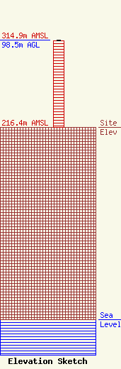
Site Elevation: 216.4 meters (710 ft) |
| Height of Structure: 97.6 meters (320 feet) |
| Overall Height Above Ground: 98.5 meters (323 feet) |
| Overall Height Above Mean Sea Level: 314.9 meters (1033 feet) |
| Owner Info | Carroll Enterprises, Inc.
P.O. Box 549
Tawas City, MI 48764
(989) 362-3417
wkjc@wkjc.com |
| Contact Info | Booth, Freret & Imlay, LLC
14356 Cape May Road
Silver Spring, MD 20904-6011
Christopher Imlay
(301) 384-5525
chris@imlaylaw.com |
