|
|
Antenna Structure Registration 1036026 |
 |
Registration Info | Registration Number: 1036026 |
| File Number: A1280060 |
| FAA Study: 97-ASO-3810-OE |
| Status: Constructed |
| Date Constructed: 10/29/1993 |
| NEPA: N |
Structure Info
| Structure Type: TOWER |
| Structure Coordinates: 34-42-2.0 N 79-6-31.0 W (NAD 83) |
| Structure Coordinates: 34-42-01.4 N 79-06-31.9 W (Converted to NAD 27) |
| Structure Address: 1521 Oak Grove Church Rd |
| Structure City: Lumberton, NC |
| Structure County: Robeson County |
| Painting & Lighting Info |
FAA Circular #: 70/7460-1J |
FAA Chapters: 3, 4, 5, 13 |
| Elevation Info |
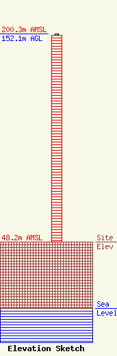
Site Elevation: 48.2 meters (158 ft) |
| Height of Structure: 151.2 meters (496 feet) |
| Overall Height Above Ground: 152.1 meters (499 feet) |
| Overall Height Above Mean Sea Level: 200.3 meters (657 feet) |
| Owner Info | Center Point Broadcasting Company LLC
3111 Bel Air Dr. #25D
Las Vegas, NV 89109
(702) 738-8376
scottcenters@yahoo.com |
| Contact Info | Center Point Broadcasting Company LLC
3111 Bel Air Dr. #25D
Las Vegas, NV 89109
Scott Centers
(702) 738-8376
scottcenters@yahoo.com |
