|
|
Antenna Structure Registration 1041044 |
 |
Registration Info | Registration Number: 1041044 |
| File Number: A0381918 |
| FAA Study: 98-ASO-0929-OE |
| Status: Constructed |
| Date Constructed: 03/02/1998 |
| FAA EMI: N |
| NEPA: N |
Structure Info
| Structure Type: TOWER |
| Structure Coordinates: 34-17-28.0 N 89-42-21.0 W (NAD 83) |
| Structure Coordinates: 34-17-27.6 N 89-42-20.7 W (Converted to NAD 27) |
| Structure Address: 3.1 Km W Of Splinter |
| Structure City: Oxford, MS |
| Structure County: Lafayette County |
| Painting & Lighting Info |
FAA Circular #: 70/7460-1J |
FAA Chapters: 3, 4, 5, 13 |
| Elevation Info |
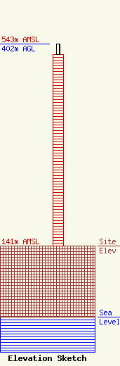
Site Elevation: 141 meters (463 ft) |
| Height of Structure: 381 meters (1250 feet) |
| Overall Height Above Ground: 402 meters (1319 feet) |
| Overall Height Above Mean Sea Level: 543 meters (1781 feet) |
| Owner Info | MISSISSIPPI AUTHORITY FOR EDUCATIONAL TELEVISION
3825 RIDGEWOOD ROAD
JACKSON, MS 39211-6463
(601) 982-6565
|
