|
|
Antenna Structure Registration 1233151 |
 |
Registration Info | Registration Number: 1233151 |
| File Number: A0251797 |
| FAA Study: 02-ASO-0654-OE |
| FAA Issue Date: 03/12/2002 |
| Status: Granted |
| FAA EMI: Y |
| NEPA: N |
Structure Info
| Structure Type: TOWER |
| Structure Coordinates: 18-16-44.8 N 65-40-7.6 W (NAD 83) |
| Structure Coordinates: 18-16-52.0 N 65-40-09.0 W (Converted to NAD 27) |
| Structure Address: 2.57 Kilometers Northwest Of Ceiba |
| Structure City: Ceiba, PR |
| Structure County: Ceiba Municipio |
| Painting & Lighting Info |
FAA Circular #: |
FAA Chapters: NONE |
Remarks: Removed expiration date from determination. Scenario 1./jjs/case#635066 |
Remarks: PRIOR STUDY 97-ASO-0650-OE |
| Elevation Info |
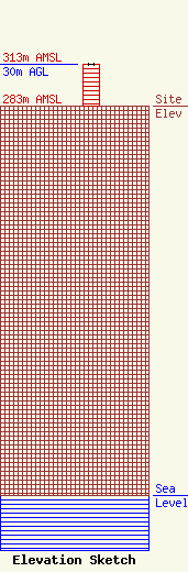
Site Elevation: 283 meters (928 ft) |
| Height of Structure: 30 meters (98 feet) |
| Overall Height Above Ground: 30 meters (98 feet) |
| Overall Height Above Mean Sea Level: 313 meters (1027 feet) |
| Info |
