|
|
Antenna Structure Registration 1031686 |
 |
Registration Info | Registration Number: 1031686 |
| File Number: A0861633 |
| FAA Study: 85-ASO-861-OE |
| FAA Issue Date: 05/23/1985 |
| Status: Constructed |
| Date Constructed: 01/01/1985 |
| FAA EMI: N |
| NEPA: N |
Structure Info
| Structure Type: TOWER |
| Structure Coordinates: 30-2-57.0 N 82-48-43.0 W (NAD 83) |
| Structure Coordinates: 30-02-56.2 N 82-48-43.5 W (Converted to NAD 27) |
| Structure Address: 9 Mi Nw |
| Structure City: Branford, FL |
| Structure County: Suwannee County |
| Painting & Lighting Info |
FCC Paragraph(s): 1, 3, 11, 21 |
Remarks: RED LIGHTS/PAINT |
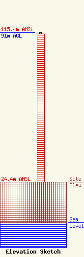
| Elevation Info |
Site Elevation: 24.4 meters (80 ft) |
| Height of Structure: 90 meters (295 feet) |
| Overall Height Above Ground: 91 meters (299 feet) |
| Overall Height Above Mean Sea Level: 115.4 meters (379 feet) |
| Owner Info | Faith Radio Network, Inc.
181000
Tallahassee, FL 32318
(850) 201-1070
scott@faithradio.us |
| Contact Info | Faith Radio Network, Inc.
181000
Tallahassee, FL 32318
Scott Beigle
(850) 201-1070
scott@faithradio.us |
