|
|
Antenna Structure Registration 1008868 |
 |
Registration Info | Registration Number: 1008868 |
| File Number: A1348056 |
| FAA Study: 97-ANE-0202-OE |
| FAA Issue Date: 06/04/1997 |
| Status: Constructed |
| Date Constructed: 01/01/1993 |
| FAA EMI: N |
| NEPA: N |
Structure Info
| Structure Type: TOWER |
| Structure Coordinates: 42-22-25.0 N 72-40-24.0 W (NAD 83) |
| Structure Coordinates: 42-22-24.7 N 72-40-25.7 W (Converted to NAD 27) |
| Structure Address: On Horse Mountain 6 Km Nw Of Northampton Ma |
| Structure City: Williamsburg, MA |
| Structure County: Hampshire County |
| Painting & Lighting Info |
FAA Circular #: 70/7460-1H |
FAA Chapters: 3, 4, 5, 13 |
Remarks: Removed expiration date from determination. Scenario 1./jjs/case#635066 |
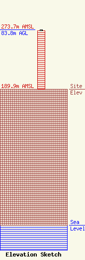
| Elevation Info |
Site Elevation: 189.9 meters (623 ft) |
| Height of Structure: 82.3 meters (270 feet) |
| Overall Height Above Ground: 83.8 meters (275 feet) |
| Overall Height Above Mean Sea Level: 273.7 meters (898 feet) |
| Owner Info | GTC Uno, LLC
PO Box 2359
Ponte Vedra Beach, FL 32004
(844) 482-8977
regulatory@gtctowers.com |
| Contact Info | GTC Uno, LLC
PO Box 2359
Ponte Vedra Beach, FL 32004
(844) 482-8977
regulatory@gtctowers.com |
