|
|
Antenna Structure Registration 1258262 |
 |
Registration Info | Registration Number: 1258262 |
| File Number: A1271964 |
| FAA Study: 2023-ASO-29630-OE |
| FAA Issue Date: 10/24/2023 |
| Status: Granted |
| Date Constructed: 05/12/2008 |
| NEPA: N |
Structure Info
| Structure Type: GTOWER |
| Structure Coordinates: 32-8-49.0 N 81-37-4.0 W (NAD 83) |
| Structure Coordinates: 32-08-48.3 N 81-37-04.6 W (Converted to NAD 27) |
| Structure Address: S End Of Vandiver Street, Pembroke Ga |
| Structure City: Pembroke, GA |
| Structure County: Bryan County |
| Painting & Lighting Info |
FAA Circular #: 70/7460-1M |
FAA Chapters: 4, 9, 15 |
Remarks: PRIOR STUDY 2005-ASO-1781-OE |
| Elevation Info |
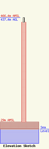
Site Elevation: 29 meters (95 ft) |
| Height of Structure: 417.9 meters (1371 feet) |
| Overall Height Above Ground: 437.4 meters (1435 feet) |
| Overall Height Above Mean Sea Level: 466.4 meters (1530 feet) |
| Owner Info | Georgia Public Telecommunications Commission
260 14th Street NW
Atlanta, GA 30318
(404) 685-2483
awoodlief@gpb.org |
| Contact Info | Gray Miller Persh LLP
2233 Wisconsin Ave., NW
Washington, DC 20007
Derek Teslik
(202) 559-7489
dteslik@graymillerpersh.com |
