|
|
Antenna Structure Registration 1235477 |
 |
Registration Info | Registration Number: 1235477 |
| File Number: A0910824 |
| FAA Study: 2009-ASO-6288-OE |
| FAA Issue Date: 11/17/2009 |
| Status: Granted |
| Date Constructed: 11/24/2006 |
| FAA EMI: N |
| NEPA: N |
Structure Info
| Structure Type: TOWER |
| Structure Coordinates: 30-47-50.8 N 83-1-0.5 W (NAD 83) |
| Structure Coordinates: 30-47-50.0 N 83-01-01.0 W (Converted to NAD 27) |
| Structure Address: 2.1 Miles Sw Of The Intersection Of Us Highway 129 And Sr 187, Echols County, Ga |
| Structure City: Statenville, GA |
| Structure County: Echols County |
| Painting & Lighting Info |
FAA Circular #: 70/7460-1K |
FAA Chapters: 3, 4, 5, 12 |
Remarks: PRIOR STUDY 2005-ASO-2689-OE |
| Elevation Info |
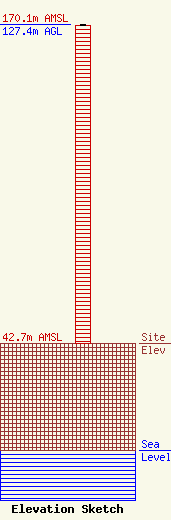
Site Elevation: 42.7 meters (140 ft) |
| Height of Structure: 127 meters (417 feet) |
| Overall Height Above Ground: 127.4 meters (418 feet) |
| Overall Height Above Mean Sea Level: 170.1 meters (558 feet) |
| Owner Info | AMERICAN FAMILY ASSOCIATION
P. O. DRAWER 2440
TUPELO, MS 38803
(662) 844-8888
JES@AFA.NET |
| Contact Info | AMERICAN FAMILY ASSOCIATION
P. O. DRAWER 2440
TUPELO, MS 38803
JESSICA HUCKABY
(662) 844-8888
JES@AFA.NET |
