|
|
Antenna Structure Registration 1216620 |
 |
Registration Info | Registration Number: 1216620 |
| File Number: A0837115 |
| FAA Study: 01-ASO-6517-OE |
| FAA Issue Date: 08/08/2001 |
| Status: Constructed |
| Date Constructed: 07/18/2001 |
| FAA EMI: N |
| NEPA: N |
Structure Info
| Structure Type: TOWER |
| Structure Coordinates: 30-23-57.2 N 83-39-24.1 W (NAD 83) |
| Structure Coordinates: 30-23-56.5 N 83-39-24.5 W (Converted to NAD 27) |
| Structure Address: 4 Miles South Of I-10 On Us 221 & Sr 55 |
| Structure City: Tallahasse, FL |
| Structure County: Madison County |
| Painting & Lighting Info |
FAA Circular #: 70/7460-1K |
FAA Chapters: 4, 8, 12 |
Remarks: PRIOR STUDY 00-ASO-5364-OE |
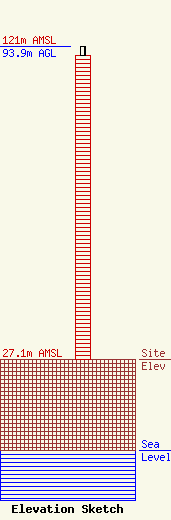
| Elevation Info |
Site Elevation: 27.1 meters (89 ft) |
| Height of Structure: 91.4 meters (300 feet) |
| Overall Height Above Ground: 93.9 meters (308 feet) |
| Overall Height Above Mean Sea Level: 121 meters (397 feet) |
| Owner Info | SBA Towers, LLC
8051 Congress Avenue
Boca Raton, FL 33487
(561) 995-7670
ERoach@sbasite.com |
| Contact Info | SBA Towers, LLC
8051 Congress Avenue
Boca Raton, FL 33487
Edward Roach
(561) 995-7670
ERoach@sbasite.com |
