|
|
Antenna Structure Registration 1228043 |
 |
Registration Info | Registration Number: 1228043 |
| File Number: A1101328 |
| FAA Study: 2018-AGL-313-OE |
| FAA Issue Date: 01/05/2018 |
| Status: Constructed |
| Date Constructed: 07/27/2001 |
| NEPA: N |
Structure Info
| Structure Type: LTOWER |
| Structure Coordinates: 43-51-42.1 N 87-46-20.8 W (NAD 83) |
| Structure Coordinates: 43-51-42.1 N 87-46-20.5 W (Converted to NAD 27) |
| Structure Address: W1545 County Road Mm (wi21185-a) |
| Structure City: Cleveland, WI |
| Structure County: Sheboygan County |
| Painting & Lighting Info |
FAA Circular #: 70/7460-1L |
FAA Chapters: 4, 8, 12 |
Remarks: PRIOR STUDY 2006-AGL-10015-OE |
| Elevation Info |
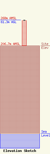
Site Elevation: 206.7 meters (678 ft) |
| Height of Structure: 59.4 meters (195 feet) |
| Overall Height Above Ground: 61.3 meters (201 feet) |
| Overall Height Above Mean Sea Level: 268 meters (879 feet) |
| Owner Info | SBA Structures, LLC
8051 Congress Avenue
Boca Raton, FL 33487
(561) 995-7670
ERoach@sbasite.com |
| Contact Info | SBA Structures, LLC
8051 Congress Avenue
Boca Raton, FL 33487
(561) 995-7670
ERoach@sbasite.com |
