|
|
Antenna Structure Registration 1257832 |
 |
Registration Info | Registration Number: 1257832 |
| File Number: A0604689 |
| FAA Study: 2008-AEA-3344-OE |
| FAA Issue Date: 08/11/2008 |
| Status: Granted |
| Date Constructed: 07/14/2008 |
| NEPA: N |
Structure Info
| Structure Type: TOWER |
| Structure Coordinates: 41-47-33.9 N 76-26-2.4 W (NAD 83) |
| Structure Coordinates: 41-47-33.6 N 76-26-03.6 W (Converted to NAD 27) |
| Structure Address: Just Off Service Drive |
| Structure City: Towanda, PA |
| Structure County: Bradford County |
| Painting & Lighting Info |
FAA Circular #: |
FAA Chapters: NONE |
Remarks: Removed expiration date from determination. Scenario 1./jjs/case#635066 |
Remarks: PRIOR FAA 2003-AEA-1454-OE. |
Remarks: Removed expiration date from determination. Scenario 1./jjs/case#635066 |
Remarks: PRIOR FAA 2003-AEA-1454-OE. |
| Elevation Info |
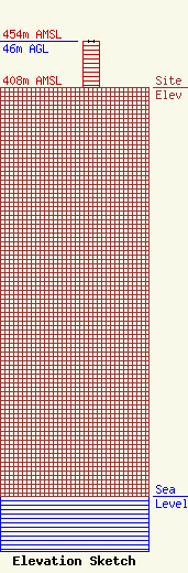
Site Elevation: 408 meters (1339 ft) |
| Height of Structure: 46 meters (151 feet) |
| Overall Height Above Ground: 46 meters (151 feet) |
| Overall Height Above Mean Sea Level: 454 meters (1490 feet) |
| Owner Info | Foster Communications
RR 5 Box 5564
Towanda, PA 18848
Greg Foster
(507) 265-3227
regulatoryfcc@conterra.com |
| Contact Info | Conterra UltraBroadband
22101 Rexford Rd, Ste 200E
Charlotte, NC 28211
VP Operation
(704) 936-1724
regulatoryfcc@conterra.com |
